Diving Cultus Lake
Getting there
There are two main road routes to Cultus lake, east bound from Hwy #1 and southbound from the city of Chilliwack.
From Hwy 1 eastbound:
Take exit #104 (#3 road) and drive south on #3 Rd for 2km's
Turn right on Tolmie Rd and drive for 100m.
Turn left onto #3 road again and drive east for 3km's
Turn left onto Yarrow central Rd (turns into Vedder Mountain Rd) and drive east for 5.8km's
Turn right on Cultus Lake Rd (turns into Columbia Valley Rd) and drive south for 2.4 km's
Arrive at the "Welcome to Cultus Lake Park" sign on right side of road (all dive site distances are from this point).
From Chilliwack southbound:
From Hwy 1 exit #119 drive south on Vedder Rd for 6 km's
Turn right onto Vedder Mountain Rd and drive west for 1 km
Turn left onto Cultus lake Rd and drive south for 2.4km's
Arrive at "Welcome to Cultus Lake Park" sign.
Ammenities
The largest urban center to Cultus lake is Chilliwack with many modern services although there are no dedicated dive shops east of Langley BC.
Yarrow is a small town with several cafes, gas stations and grocery stores.
Along the lake there are two communities, Cultus Lake townsite at the northern end and Lindell Beach at the southern end. Cultus Lake has several cafes and a gas station but business hours in both Yarrow and Cultus Lake townsite vary greatly, depending on the day and time of year (winter is off season for tourism). Lindell Beach is a closed community with no amentities for the public.
911 emergency access is in effect at Cultus Lake although cell reception may be sporatic. There is a Volunteer fire hall in Cultus Lake and a Provincial Park office at Entrance Bay.
Parking along the lake roadside is allowed from September to June but prohibited in the summer months. Parking in the provicial park sites is from dawn till dusk. Parking is prohibited at Lindell Beach and Main Beach has townsite operated pay parking. Parking at Jade Bay is allowed in the winter but only for boat trailer vehicles in summer. Both Entrance Bay and Maple Bay are closed in the winter.
For boat launching there are ramps at Maple Bay and Jade Bay (Jade Bay is open year round).
For more information regarding amenities within the park refer to the Provincial Park Brochure: http://www.env.gov.bc.ca/bcparks/explore/parkpgs/cultus_lk/
What to Expect
Cultus lake is a very popular summer destination with large crowds, limited parking and many powered pleasure craft. Unfortunately, many operators are unaware or neglectful of divers and/or dive floats and swim zones. Divers should exercise extreme caution always and try to plan dives earlier in the day to avoid the crowds.
In the winter, Cultus becomes a "ghost town" of a lake and there are few, if any, visitors or boaters (other than small aluminum fishing skiffs). Divers should plan to be self sufficient and not rely on assistance from passers by.
Temperatures can range from the low 60's (F) near the surface in the summer to low 30's (F) in the winter with ice occasionally and only temporarily forming. Bottom temps are usually in the low 40's year round. Very distinct thermoclines will be encountered.
Visibility can range from 30' to 3' and may vary depending on depth. Summer and winter lake turnovers, algae blooms and storm runoff may all contribute to variations in visibility. The lake substrate is comprised of unsolidified detritus and will cause severe siltouts if disturbed.
There are no currents other than at the northern and southern ends (not appreciable) but surface winds may cause standing waves and severe chilling of exposed divers in the winter.
Cultus Lake Dive Sites
West Shore Dive Sites
As to date, the southern and western shores of Cultus lake are accessable by boat only (though work is being done to gain access via Lindell Beach for research purposes). As dive locations are explored along these shores they will be added.
Lindell Beach (south shore):
Currently, shore based diving is not viable at Lindel beach due to non local parking restrictions in the small townsite. This is an area where a large number of mature Pygmy Sculpins have be collected in the past and the project is working to gain access to the shoreline for research purposes. In the winter one can walk in through Maple Bay and dive the east side of Lindell Beach from that entry point.
The Jumping Cliffs:
In the summer of 2010 a small group of us dove the area known by locals as the "Jumping cliffs", along the southwestern shore of the lake. Accessible only by boat (no parking at Lindell beach) this location offers some very nice wall diving with drops down to 135'. Dark, ledgy, with big rock blocks and boulders to poke around. A lot more exploration is needed here.
The DND lands:
Another, boat access only, site along the mid western shoreline controlled by the Department of National Defense. Urban legend has it that a Bailey Bridge collapsed while under construction somewhere in the area and it, along with some vehicles, went to the bottom. Who will be the first to find a Churchill Tank?
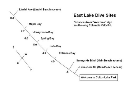
East Shore Dive Sites
There are a number of dive sites along the eastern edge of Cultus lake that have easy access and entry points as well as some amenities depending on the season.
Main Beach:
Main Beach is accessed from either Lakeshore Dr. or Sunnyside Blvd. where there are two large townsite run parking lots. Parking is not an issue during the off season but it can be crowded on sunny summer weekdays and most summer weekends. The non silty base around the large dock complex and shallow sloping bottom creates a good location for beginner classes or divers wishing to test out their gear (the local dive club holds their pumpkin carving contests here) but for more serious diving the shallow bottom soon becomes a liability. Depths are limited to 25' or less with large patches of Milfoil and Egeria to contend with. During the summer many boats cruise and tie up to the south and west of the dock complex and divers should be extremely cautious if venturing that way. Another unusual danger in the summer are people actually jumping off of the docks on top of you. Don't say you were never warned!
Big washrooms (limited hours in the winter) and outdoor showers in the summer.
Entrance Bay:
This location, and Jade Bay in the winter, provides divers with a variety of options for dives to depths of 80-85' or so. Entrance Bay has big summer only washroom and picnic facilities, is popular and can become crowded; but if you arrive early in the day (before the sun worshippers) you can usually get your dives in. The Entrance Bay parking lot also closes sometime in the late fall though access can still be gained via the Jade Bay lot. There are two main areas to dive here; the North cove/old marina site and the Entrance bay shoreline.
The North Cove and old Marina site.
From the dock at the north end of the Entrance Bay beach area, dive north across the small cove until you find reminants of the old marina on the far side. The bottom in the cove is sterile silt, with only a few logs or bottles to amuse but it is a good crossing for practicing your compass skills. Depths to 85'. Once on the far shore, you can return to the Entrance Bay side by following the shore to the right around the cove. You will transition from sloping silt and sand to ledgy stratified rockwalls with the occasional large tree trunk to break things up.
The Entrance Bay shoreline.
From the northern dock you can also head south, along the Entrance Bay shoreline, towards the southern dock, following which ever depth contour you wish. An easy dive plan is to go deeper one way till one hits halfway turn pressure and then reverse and return at a progressively shallower depth. Bailout, if needed, is straight up slope. This shoreline is actually a large alluvial fan that has an initial sandy shallow portion (where people swim) followed by a steeper 45 degree slope that begins to level off again at about 60-70'. The littoral zone runs the length of the shore and lies between depths of about 8-20'. In the summer and fall it is a great place to see large schools of fish like shiners and sticklebacks. One of the better aspects of this site is that it is markered off as a "No Boating" zone so you are somewhat less likely to be hit by a speeding jetski here (no guarantees though).
Jade Bay:
A good winter alternative that allows access north to Entrance Bay or south to the shoreline beyond. There are year round outhouses in the shoreline trees at the north end of the parking lot. In the summer it is a busy boat launch and common sense dictates a cautious approach if attempting to dive then. Immediately to the south of the boat launch starting at about 30' are some Salmon spawning grounds. Here the slope falls in a series of drops and level basins where the gravel is swept clear of silt. These are a protected species so extreme caution should be taken not to disturb either the spawning sites or harass the fish if they are active. Last year a group of us were fortunate to observe these fish in action.
Just a little further south of Jade Bay are some sections of a Bailey Bridge piled atop each other; and beyond them is the remains of a section of MkIII bridging equipment (two plywood boats and connecting girders). How they got there, and whether there are any more in the area, is a mystery to be solved. Beyond this, the rocky shoreline leads towards Spring Bay and has yet to be explored.
Spring Bay:
There is a small pullout just past Jade Bay for a nice little spot called Spring Bay. In the summer the parking lot fills fast but in the off season it is a great spot for moderate depth diving. There are year round outhouses and picnic tables. Underwater, the bay forms an uneven bowl of sorts and it is easy to become disoriented as to direction if relying on slope features alone. A compass is generally required if you want to know where you are going. Large logs, weedy sections, bare spots, silt, rocky plateaus... they are all in this bay where depths average 45' or so.
Honeymoon Bay and the Delta Grove campground shoreline:
Diving along the shoreline here is somewhat seasonally dependant. During the late fall winter and early spring one can park in pullouts along the Columbia Valley road and walk across for shore access but during the summer season (June to Sept.) cars will be towed from there. The other options for the summer are to either rent a campsite and dive from it or use a boat for access. The UW topography is similar to that of Entrance Bay as both are situated on alluvial fan formations but the slope is a little less here. The bottom drops off at aprox. 30 degrees down to about 70' where it eases off as it decends slowly towards the distant deep center of the lake. A well defined littoral zone, schools of fish, large submerged logs; rock rubble gives way to a silt bottom.
Maple Bay:
The day use area at Maple Bay is open during the summer but closes in the fall. When open there are good picnic and modern washroom facilities similar to Main Beach and Entrance Bay. Careful consideration should be made if diving here during tourist season as the marked swimming/no boating zone is small and pleasure craft traffic is high in this area. From the beach one can either dive north or south along the shoreline.
South shoreline.
Diving Southwards from the beach the gravel bottom drops away at approximately 30 degrees and soon becomes silty as it flattens out at 60 - 70'. Large areas of Cyanobacteria cover much of the littoral zone and there is a sense of stagnation not present in other parts of the lake. As the shore curves west to become Lindell beach one can find old mooring anchors and other similar debris. Large logs, a poor littoral zone and scattered small fish.
North shoreline.
Yet to be explored.
